<!DOCTYPE html> <html lang="en" > <!-- Mirrored from geohelm.docs.acugis.com/en/latest/components/postgis/index.html by HTTrack Website Copier/3.x [XR&CO'2014], Thu, 13 Jul 2023 23:22:03 GMT --> <!-- Added by HTTrack --><meta http-equiv="content-type" content="text/html;charset=utf-8" /><!-- /Added by HTTrack --> <head> <meta charset="utf-8"> <meta name="viewport" content="width=device-width, initial-scale=1.0"> <title>PostGIS — AcuGIS GeoHelm 0.4.3 documentation</title> <!-- AcuGIS 1 --> <!--[if lt IE 9]> <script src="../../_static/js/html5shiv.min.js"></script> <![endif]--> <script type="text/javascript" id="documentation_options" data-url_root="../../" src="../../_static/documentation_options.js"></script> <script type="text/javascript" src="../../_static/jquery.js"></script> <script type="text/javascript" src="../../_static/underscore.js"></script> <script type="text/javascript" src="../../_static/doctools.js"></script> <script type="text/javascript" src="../../_static/language_data.js"></script> <script async="async" type="text/javascript" src="../../../../_/static/javascript/readthedocs-doc-embed.js"></script> <script type="text/javascript" src="../../_static/js/theme.js"></script> <link rel="stylesheet" href="../../_static/css/theme.css" type="text/css" /> <link rel="stylesheet" href="../../_static/pygments.css" type="text/css" /> <link rel="stylesheet" href="../../_static/custom.css" type="text/css" /> <link rel="index" title="Index" href="../../genindex.html" /> <link rel="search" title="Search" href="../../search.html" /> <link rel="next" title="PgRouting" href="../pgrouting/index.html" /> <link rel="prev" title="PostgreSQL" href="../postgresql/index.html" /> <!-- RTD Extra Head --> <link rel="stylesheet" href="../../../../_/static/css/readthedocs-doc-embed.css" type="text/css" /> <script type="application/json" id="READTHEDOCS_DATA">{"ad_free": false, "api_host": "https://readthedocs.org", "builder": "sphinx", "canonical_url": null, "docroot": "/docs/", "features": {"docsearch_disabled": false}, "global_analytics_code": "UA-17997319-1", "language": "en", "page": "components/postgis/index", "programming_language": "perl", "project": "geohelm", "proxied_api_host": "/_", "source_suffix": ".rst", "subprojects": {}, "theme": "sphinx_rtd_theme", "user_analytics_code": "", "version": "latest"}</script> <!-- Using this variable directly instead of using `JSON.parse` is deprecated. The READTHEDOCS_DATA global variable will be removed in the future. --> <script type="text/javascript"> READTHEDOCS_DATA = JSON.parse(document.getElementById('READTHEDOCS_DATA').innerHTML); </script> <script type="text/javascript" src="../../../../_/static/javascript/readthedocs-analytics.js" async="async"></script> <!-- end RTD <extrahead> --> </head> <div id="header" style="position: fixed; height: 70px; padding-bottom: 20px; overflow: hidden; background-color: #28728d; display: block; z-index: 1000; width: 100%;"> <div class="acugis_geosuite" style="color:#fff!important; padding-left:30px; font-size:26px; padding-top: 20px;"><a href="https://geohelm.docs.acugis.com/" style="color:#fff!important; text-decoration:none!important">AcuGIS GeoHelm</a></div> </div> </div> <body class="wy-body-for-nav"> <div class="wy-grid-for-nav"> <nav data-toggle="wy-nav-shift" class="wy-nav-side"> <div class="wy-side-scroll"> <div id="header2"> </div> <div class="wy-menu wy-menu-vertical" data-spy="affix" role="navigation" aria-label="main navigation" style="padding-top: 45px;"> <p class="caption"><span class="caption-text">Getting Started</span></p> <ul> <li class="toctree-l1"><a class="reference internal" href="../../intro.html">Intro</a></li> <li class="toctree-l1"><a class="reference internal" href="../../installing.html">Installation</a></li> <li class="toctree-l1"><a class="reference internal" href="../../layout.html">Layout</a></li> <li class="toctree-l1"><a class="reference internal" href="../../webmin.html">Control Panel</a></li> <li class="toctree-l1"><a class="reference internal" href="../../webmin.html#removing-the-control-panel">Removing the Control Panel</a></li> </ul> <p class="caption"><span class="caption-text">PostGIS</span></p> <ul class="current"> <li class="toctree-l1"><a class="reference internal" href="../createdb/index.html">Create Database</a></li> <li class="toctree-l1"><a class="reference internal" href="../postgresql/index.html">PostgreSQL</a></li> <li class="toctree-l1 current"><a class="current reference internal" href="#">PostGIS</a><ul> <li class="toctree-l2"><a class="reference internal" href="#installing-postgis">Installing PostGIS</a></li> <li class="toctree-l2"><a class="reference internal" href="#command-line">Command Line</a></li> <li class="toctree-l2"><a class="reference internal" href="#extensions-tool">Extensions Tool</a></li> </ul> </li> <li class="toctree-l1"><a class="reference internal" href="../pgrouting/index.html">PgRouting</a></li> <li class="toctree-l1"><a class="reference internal" href="../shp2pgsql/index.html">shp2pgsql</a></li> <li class="toctree-l1"><a class="reference internal" href="../osm2pgsql/index.html">osm2pgsql</a></li> <li class="toctree-l1"><a class="reference internal" href="../raster2pgsql/index.html">raster2pgsql</a></li> </ul> <p class="caption"><span class="caption-text">GeoServer</span></p> <ul> <li class="toctree-l1"><a class="reference internal" href="../../geoserver/admin/index.html">Access</a></li> <li class="toctree-l1"><a class="reference internal" href="../../geoserver/geoservers/index.html">Overview</a></li> <li class="toctree-l1"><a class="reference internal" href="../../geoserver/tomcat/index.html">Apache Tomcat</a></li> <li class="toctree-l1"><a class="reference internal" href="../../geoserver/workspace/index.html">Create a Workspace</a></li> <li class="toctree-l1"><a class="reference internal" href="../../geoserver/store/index.html">Create Store</a></li> <li class="toctree-l1"><a class="reference internal" href="../../geoserver/layer/index.html">Add Layer</a></li> <li class="toctree-l1"><a class="reference internal" href="../../geoserver/shp/index.html">Load ESRI Shapefile</a></li> <li class="toctree-l1"><a class="reference internal" href="../../geoserver/styles/index.html">Styles</a></li> </ul> <p class="caption"><span class="caption-text">pg_tileserv</span></p> <ul> <li class="toctree-l1"><a class="reference internal" href="../pgtileserv/index.html">pg_tileserv</a></li> <li class="toctree-l1"><a class="reference internal" href="../pgfeatureserv/index.html">pg_featureserv</a></li> </ul> <p class="caption"><span class="caption-text">Database Operations</span></p> <ul> <li class="toctree-l1"><a class="reference internal" href="../../database/snapshot/index.html">Database Snapshots</a></li> <li class="toctree-l1"><a class="reference internal" href="../../database/clone/index.html">Clone Database</a></li> <li class="toctree-l1"><a class="reference internal" href="../../database/restore/index.html">Restore Database</a></li> </ul> <p class="caption"><span class="caption-text">QGIS</span></p> <ul> <li class="toctree-l1"><a class="reference internal" href="../../qgis/home.html">Introduction</a></li> <li class="toctree-l1"><a class="reference internal" href="../../qgis/pgservice.html">pg_service.conf</a></li> <li class="toctree-l1"><a class="reference internal" href="../../qgis/qgis.html">Create a QGIS Project</a></li> <li class="toctree-l1"><a class="reference internal" href="../../qgis/publish.html">Publish Layers</a></li> <li class="toctree-l1"><a class="reference internal" href="../../qgis/style-only.html">Publish Styles Only</a></li> </ul> <p class="caption"><span class="caption-text">LeafletJS</span></p> <ul> <li class="toctree-l1"><a class="reference internal" href="../../apps/choropleth.html">Leaflet Choropleth App</a></li> <li class="toctree-l1"><a class="reference internal" href="../../apps/geojson.html">Leaflet GeoJson</a></li> <li class="toctree-l1"><a class="reference internal" href="../../apps/php.html">Leaflet and PHP</a></li> </ul> <p class="caption"><span class="caption-text">Resources</span></p> <ul> <li class="toctree-l1"><a class="reference internal" href="../../resources/documents.html">Documentation</a></li> <li class="toctree-l1"><a class="reference internal" href="../../resources/css.html">CSS</a></li> <li class="toctree-l1"><a class="reference internal" href="../../resources/security.html">Security</a></li> <li class="toctree-l1"><a class="reference internal" href="../../resources/nagios.html">Nagios</a></li> <li class="toctree-l1"><a class="reference internal" href="../../resources/support.html">Project Support</a></li> <li class="toctree-l1"><a class="reference internal" href="../../resources/commercial.html">Commercial Support</a></li> <li class="toctree-l1"><a class="reference internal" href="../../resources/license.html">License</a></li> </ul> </div> </div> </nav> <section data-toggle="wy-nav-shift" class="wy-nav-content-wrap"> <nav class="wy-nav-top" aria-label="top navigation"> <i data-toggle="wy-nav-top" class="fa fa-bars"></i> <a href="../../index-2.html">AcuGIS GeoHelm</a> </nav> <div class="wy-nav-content"> <div class="rst-content"> <div role="navigation" aria-label="breadcrumbs navigation"> <ul class="wy-breadcrumbs"> <li><a href="../../index-2.html" class="icon icon-home"></a> »</li> <li>PostGIS</li> <li class="wy-breadcrumbs-aside"> <a href="https://github.com/AcuGIS/GeoHelm/blob/master/docs/components/postgis/index.rst" class="fa fa-github"> Edit on GitHub</a> </li> </ul> <hr/> </div> <div role="main" class="document" itemscope="itemscope" itemtype="http://schema.org/Article"> <div itemprop="articleBody"> <div class="section" id="postgis"> <h1><a class="toc-backref" href="#id1">PostGIS</a><a class="headerlink" href="#postgis" title="Permalink to this headline">¶</a></h1> <div class="contents topic" id="table-of-contents"> <p class="topic-title">Table of Contents</p> <ul class="simple"> <li><a class="reference internal" href="#postgis" id="id1">PostGIS</a><ul> <li><a class="reference internal" href="#installing-postgis" id="id2">Installing PostGIS</a></li> <li><a class="reference internal" href="#command-line" id="id3">Command Line</a></li> <li><a class="reference internal" href="#extensions-tool" id="id4">Extensions Tool</a></li> </ul> </li> </ul> </div> <div class="section" id="installing-postgis"> <h2><a class="toc-backref" href="#id2">Installing PostGIS</a><a class="headerlink" href="#installing-postgis" title="Permalink to this headline">¶</a></h2> <p>PostGIS can be enabled on your PostgreSQL database via the Extension tab or via Command Line.</p> </div> <div class="section" id="command-line"> <h2><a class="toc-backref" href="#id3">Command Line</a><a class="headerlink" href="#command-line" title="Permalink to this headline">¶</a></h2> <p>To install via command line:</p> <ol class="arabic simple"> <li>Connect to PostgreSQL</li> </ol> <div class="highlight-console notranslate"><div class="highlight"><pre><span></span><span class="gp">root@postgis:~# </span>su<span class="w"> </span>-<span class="w"> </span>postgres <span class="gp">postgres@postgis:~$ </span>psql <span class="go">psql (15.3 (Ubuntu 15.3-1.pgdg22.04+1))</span> <span class="go">Type "help" for help.</span> <span class="go">postgres=#</span> </pre></div> </div> <ol class="arabic simple" start="2"> <li>Connect to target database.</li> </ol> <div class="highlight-console notranslate"><div class="highlight"><pre><span></span><span class="go">postgres=# \c demodb</span> <span class="go">You are now connected to database "demodb" as user "postgres".</span> <span class="go">demodb=#</span> </pre></div> </div> <ol class="arabic simple" start="3"> <li>Install the PostGIS extension.</li> </ol> <div class="highlight-console notranslate"><div class="highlight"><pre><span></span><span class="go">demodb=# create extension postgis;</span> <span class="go">CREATE EXTENSION</span> <span class="go">demodb=#</span> </pre></div> </div> <p>You can install includes fuzzy_match_string, tiger, postgis_topology, postgis_raster using above.</p> <ol class="arabic simple" start="4"> <li>Verify the installation via command line or the PostgreSQL Management Page</li> </ol> <div class="highlight-console notranslate"><div class="highlight"><pre><span></span><span class="go">demodb=# \d</span> <span class="go"> List of relations</span> <span class="go">Schema | Name | Type | Owner</span> <span class="go">--------+-------------------+-------+----------</span> <span class="go">public | geography_columns | view | postgres</span> <span class="go">public | geometry_columns | view | postgres</span> <span class="go">public | raster_columns | view | postgres</span> <span class="go">public | raster_overviews | view | postgres</span> <span class="go">public | spatial_ref_sys | table | postgres</span> <span class="gp gp-VirtualEnv">(5 rows)</span> </pre></div> </div> </div> <div class="section" id="extensions-tool"> <h2><a class="toc-backref" href="#id4">Extensions Tool</a><a class="headerlink" href="#extensions-tool" title="Permalink to this headline">¶</a></h2> <p>
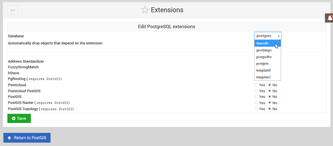
To install using the PostGIS/PgRouting Extension installer, click on the Extensions tab as shown below.</p> <img alt="../../_images/postgis-tab1.png" src="../../_images/postgis-tab1.png" /> <ol class="arabic simple"> <li>Select the target database from the drop-down as shown below.</li> </ol> <img alt="../../_images/postgis-select-db1.png" src="../../_images/postgis-select-db1.png" /> <div class="admonition note"> <p class="first admonition-title">Note</p> <p class="last">
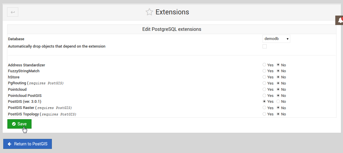
You must FIRST install PostGIS prior to installing any other of the listed extensions.</p> </div> <ol class="arabic simple" start="2"> <li>Tick the PostGIS select button and then click the Save button as show below:</li> </ol> <img alt="../../_images/postgis-enable1.png" src="../../_images/postgis-enable1.png" /> <ol class="arabic simple" start="3"> <li>
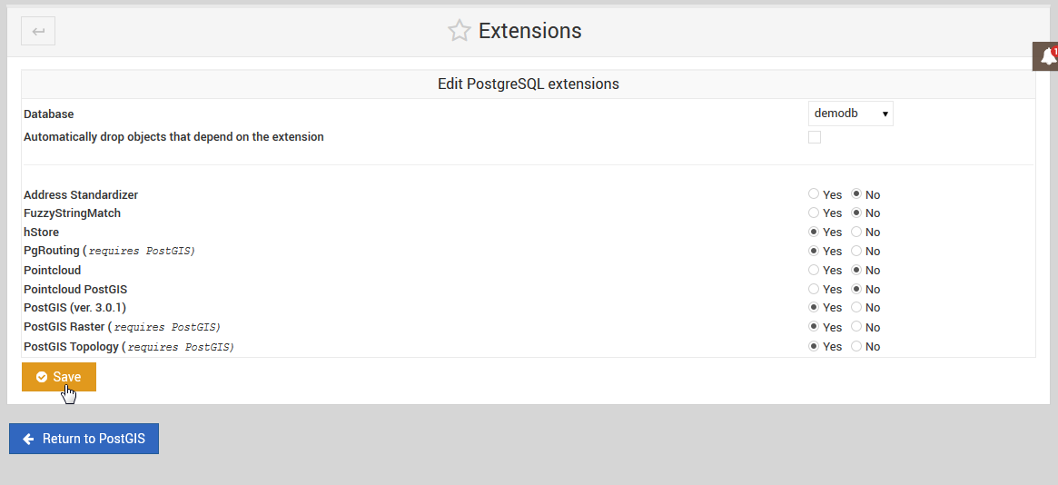
Once PostGIS has been installed on a target database, you can then return to install additional extensions:</li> </ol> <img alt="../../_images/postgis-install-others1.png" src="../../_images/postgis-install-others1.png" /> <div class="admonition note"> <p class="first admonition-title">Note</p> <p class="last">You can also un-install Extensions using above.</p> </div> </div> </div> </div> </div> <footer> <div class="rst-footer-buttons" role="navigation" aria-label="footer navigation"> <a href="../pgrouting/index.html" class="btn btn-neutral float-right" title="PgRouting" accesskey="n" rel="next">Next <span class="fa fa-arrow-circle-right"></span></a> <a href="../postgresql/index.html" class="btn btn-neutral float-left" title="PostgreSQL" accesskey="p" rel="prev"><span class="fa fa-arrow-circle-left"></span> Previous</a> </div> <hr/> <div role="contentinfo"> <p> © Copyright acugis <span class="commit"> Revision <code>db2a027e</code>. </span> </p> </div> Built with <a href="http://sphinx-doc.org/">Sphinx</a> using a <a href="https://github.com/rtfd/sphinx_rtd_theme">theme</a> provided by <a href="https://readthedocs.org/">Read the Docs</a>. </footer> </div> </div> </section> </div> <div class="rst-versions" data-toggle="rst-versions" role="note" aria-label="versions"> <span class="rst-current-version" data-toggle="rst-current-version"> <span class="fa fa-book"> Read the Docs</span> v: latest <span class="fa fa-caret-down"></span> </span> <div class="rst-other-versions"> <dl> <dt>Versions</dt> <dd><a href="../../index.html">latest</a></dd> </dl> <dl> <dt>Downloads</dt> <dd><a href="http://geohelm.docs.acugis.com/_/downloads/en/latest/pdf/">pdf</a></dd> <dd><a href="http://geohelm.docs.acugis.com/_/downloads/en/latest/htmlzip/">html</a></dd> <dd><a href="http://geohelm.docs.acugis.com/_/downloads/en/latest/epub/">epub</a></dd> </dl> <dl> <dt>On Read the Docs</dt> <dd> <a href="http://readthedocs.org/projects/geohelm/?fromdocs=geohelm">Project Home</a> </dd> <dd> <a href="http://readthedocs.org/builds/geohelm/?fromdocs=geohelm">Builds</a> </dd> </dl> </div> </div> <script type="text/javascript"> jQuery(function () { SphinxRtdTheme.Navigation.enable(true); }); </script> </body> <!-- Mirrored from geohelm.docs.acugis.com/en/latest/components/postgis/index.html by HTTrack Website Copier/3.x [XR&CO'2014], Thu, 13 Jul 2023 23:22:05 GMT --> </html>