<!DOCTYPE html>
<html lang="en" >

<!-- Mirrored from geohelm.docs.acugis.com/en/latest/qgis/publish.html by HTTrack Website Copier/3.x [XR&CO'2014], Thu, 13 Jul 2023 23:23:00 GMT -->
<!-- Added by HTTrack --><meta http-equiv="content-type" content="text/html;charset=utf-8" /><!-- /Added by HTTrack -->
<head>
  <meta charset="utf-8">
  
  <meta name="viewport" content="width=device-width, initial-scale=1.0">
  
  <title>Publish Layers &mdash; AcuGIS GeoHelm 0.4.3 documentation</title>


<!-- AcuGIS 1 -->


  <!--[if lt IE 9]>
    <script src="../_static/js/html5shiv.min.js"></script>
  <![endif]-->
  
    
      <script type="text/javascript" id="documentation_options" data-url_root="../" src="../_static/documentation_options.js"></script>
        <script type="text/javascript" src="../_static/jquery.js"></script>
        <script type="text/javascript" src="../_static/underscore.js"></script>
        <script type="text/javascript" src="../_static/doctools.js"></script>
        <script type="text/javascript" src="../_static/language_data.js"></script>
        <script async="async" type="text/javascript" src="../../../_/static/javascript/readthedocs-doc-embed.js"></script>
    
    <script type="text/javascript" src="../_static/js/theme.js"></script>


  <link rel="stylesheet" href="../_static/css/theme.css" type="text/css" />
  <link rel="stylesheet" href="../_static/pygments.css" type="text/css" />
  <link rel="stylesheet" href="../_static/custom.css" type="text/css" />
    <link rel="index" title="Index" href="../genindex.html" />
    <link rel="search" title="Search" href="../search.html" />
    <link rel="next" title="Publish Styles Only" href="style-only.html" />
    <link rel="prev" title="Create a QGIS Project" href="qgis.html" /> 

<!-- RTD Extra Head -->

<link rel="stylesheet" href="../../../_/static/css/readthedocs-doc-embed.css" type="text/css" />

<script type="application/json" id="READTHEDOCS_DATA">{"ad_free": false, "api_host": "https://readthedocs.org", "builder": "sphinx", "canonical_url": null, "docroot": "/docs/", "features": {"docsearch_disabled": false}, "global_analytics_code": "UA-17997319-1", "language": "en", "page": "qgis/publish", "programming_language": "perl", "project": "geohelm", "proxied_api_host": "/_", "source_suffix": ".rst", "subprojects": {}, "theme": "sphinx_rtd_theme", "user_analytics_code": "", "version": "latest"}</script>

<!--
Using this variable directly instead of using `JSON.parse` is deprecated.
The READTHEDOCS_DATA global variable will be removed in the future.
-->
<script type="text/javascript">
READTHEDOCS_DATA = JSON.parse(document.getElementById('READTHEDOCS_DATA').innerHTML);
</script>

<script type="text/javascript" src="../../../_/static/javascript/readthedocs-analytics.js" async="async"></script>

<!-- end RTD <extrahead> -->
</head>


                                                                <div id="header" style="position: fixed; height: 70px; padding-bottom: 20px; overflow: hidden; background-color: #28728d;  display: block; z-index: 1000; width: 100%;">
        <div class="acugis_geosuite" style="color:#fff!important; padding-left:30px; font-size:26px; padding-top: 20px;"><a href="https://geohelm.docs.acugis.com/" style="color:#fff!important; text-decoration:none!important">AcuGIS GeoHelm</a></div>

      </div>


</div>
<body class="wy-body-for-nav">

   
  <div class="wy-grid-for-nav">
    
    <nav data-toggle="wy-nav-shift" class="wy-nav-side">
      <div class="wy-side-scroll">
        
        <div id="header2"> </div>


        <div class="wy-menu wy-menu-vertical" data-spy="affix" role="navigation" aria-label="main navigation" style="padding-top: 45px;">


              <p class="caption"><span class="caption-text">Getting Started</span></p>
<ul>
<li class="toctree-l1"><a class="reference internal" href="../intro.html">Intro</a></li>
<li class="toctree-l1"><a class="reference internal" href="../installing.html">Installation</a></li>
<li class="toctree-l1"><a class="reference internal" href="../layout.html">Layout</a></li>
<li class="toctree-l1"><a class="reference internal" href="../webmin.html">Control Panel</a></li>
<li class="toctree-l1"><a class="reference internal" href="../webmin.html#removing-the-control-panel">Removing the Control Panel</a></li>
</ul>
<p class="caption"><span class="caption-text">PostGIS</span></p>
<ul>
<li class="toctree-l1"><a class="reference internal" href="../components/createdb/index.html">Create Database</a></li>
<li class="toctree-l1"><a class="reference internal" href="../components/postgresql/index.html">PostgreSQL</a></li>
<li class="toctree-l1"><a class="reference internal" href="../components/postgis/index.html">PostGIS</a></li>
<li class="toctree-l1"><a class="reference internal" href="../components/pgrouting/index.html">PgRouting</a></li>
<li class="toctree-l1"><a class="reference internal" href="../components/shp2pgsql/index.html">shp2pgsql</a></li>
<li class="toctree-l1"><a class="reference internal" href="../components/osm2pgsql/index.html">osm2pgsql</a></li>
<li class="toctree-l1"><a class="reference internal" href="../components/raster2pgsql/index.html">raster2pgsql</a></li>
</ul>
<p class="caption"><span class="caption-text">GeoServer</span></p>
<ul>
<li class="toctree-l1"><a class="reference internal" href="../geoserver/admin/index.html">Access</a></li>
<li class="toctree-l1"><a class="reference internal" href="../geoserver/geoservers/index.html">Overview</a></li>
<li class="toctree-l1"><a class="reference internal" href="../geoserver/tomcat/index.html">Apache Tomcat</a></li>
<li class="toctree-l1"><a class="reference internal" href="../geoserver/workspace/index.html">Create a Workspace</a></li>
<li class="toctree-l1"><a class="reference internal" href="../geoserver/store/index.html">Create Store</a></li>
<li class="toctree-l1"><a class="reference internal" href="../geoserver/layer/index.html">Add Layer</a></li>
<li class="toctree-l1"><a class="reference internal" href="../geoserver/shp/index.html">Load ESRI Shapefile</a></li>
<li class="toctree-l1"><a class="reference internal" href="../geoserver/styles/index.html">Styles</a></li>
</ul>
<p class="caption"><span class="caption-text">pg_tileserv</span></p>
<ul>
<li class="toctree-l1"><a class="reference internal" href="../components/pgtileserv/index.html">pg_tileserv</a></li>
<li class="toctree-l1"><a class="reference internal" href="../components/pgfeatureserv/index.html">pg_featureserv</a></li>
</ul>
<p class="caption"><span class="caption-text">Database Operations</span></p>
<ul>
<li class="toctree-l1"><a class="reference internal" href="../database/snapshot/index.html">Database Snapshots</a></li>
<li class="toctree-l1"><a class="reference internal" href="../database/clone/index.html">Clone Database</a></li>
<li class="toctree-l1"><a class="reference internal" href="../database/restore/index.html">Restore Database</a></li>
</ul>
<p class="caption"><span class="caption-text">QGIS</span></p>
<ul class="current">
<li class="toctree-l1"><a class="reference internal" href="home.html">Introduction</a></li>
<li class="toctree-l1"><a class="reference internal" href="pgservice.html">pg_service.conf</a></li>
<li class="toctree-l1"><a class="reference internal" href="qgis.html">Create a QGIS Project</a></li>
<li class="toctree-l1 current"><a class="current reference internal" href="#">Publish Layers</a><ul>
<li class="toctree-l2"><a class="reference internal" href="#install-geocat-bridge">Install GeoCat Bridge</a></li>
<li class="toctree-l2"><a class="reference internal" href="#add-server">Add Server</a></li>
<li class="toctree-l2"><a class="reference internal" href="#view-layers">View Layers</a></li>
<li class="toctree-l2"><a class="reference internal" href="#styles">Styles</a></li>
<li class="toctree-l2"><a class="reference internal" href="#publish-styles-only">Publish Styles Only</a></li>
<li class="toctree-l2"><a class="reference internal" href="#summary">Summary</a></li>
</ul>
</li>
<li class="toctree-l1"><a class="reference internal" href="style-only.html">Publish Styles Only</a></li>
</ul>
<p class="caption"><span class="caption-text">LeafletJS</span></p>
<ul>
<li class="toctree-l1"><a class="reference internal" href="../apps/choropleth.html">Leaflet Choropleth App</a></li>
<li class="toctree-l1"><a class="reference internal" href="../apps/geojson.html">Leaflet GeoJson</a></li>
<li class="toctree-l1"><a class="reference internal" href="../apps/php.html">Leaflet and PHP</a></li>
</ul>
<p class="caption"><span class="caption-text">Resources</span></p>
<ul>
<li class="toctree-l1"><a class="reference internal" href="../resources/documents.html">Documentation</a></li>
<li class="toctree-l1"><a class="reference internal" href="../resources/css.html">CSS</a></li>
<li class="toctree-l1"><a class="reference internal" href="../resources/security.html">Security</a></li>
<li class="toctree-l1"><a class="reference internal" href="../resources/nagios.html">Nagios</a></li>
<li class="toctree-l1"><a class="reference internal" href="../resources/support.html">Project Support</a></li>
<li class="toctree-l1"><a class="reference internal" href="../resources/commercial.html">Commercial Support</a></li>
<li class="toctree-l1"><a class="reference internal" href="../resources/license.html">License</a></li>
</ul>


        </div>
        
      </div>
    </nav>

    <section data-toggle="wy-nav-shift" class="wy-nav-content-wrap">

      
      <nav class="wy-nav-top" aria-label="top navigation">
        
          <i data-toggle="wy-nav-top" class="fa fa-bars"></i>
          <a href="../index-2.html">AcuGIS GeoHelm</a>
        
      </nav>


      <div class="wy-nav-content">
        
        <div class="rst-content">


<div role="navigation" aria-label="breadcrumbs navigation">

  <ul class="wy-breadcrumbs">
    
      <li><a href="../index-2.html" class="icon icon-home"></a> &raquo;</li>
        
      <li>Publish Layers</li>
    
    
      <li class="wy-breadcrumbs-aside">


              <a href="https://github.com/AcuGIS/GeoHelm/blob/master/docs/qgis/publish.rst" class="fa fa-github"> Edit on GitHub</a>


      </li>
    
  </ul>

  
  <hr/>
</div>
          <div role="main" class="document" itemscope="itemscope" itemtype="http://schema.org/Article">
           <div itemprop="articleBody">
            
  <div class="section" id="publish-layers">
<h1><a class="toc-backref" href="#id3">Publish Layers</a><a class="headerlink" href="#publish-layers" title="Permalink to this headline">¶</a></h1>
<div class="contents topic" id="table-of-contents">
<p class="topic-title">Table of Contents</p>
<ul class="simple">
<li><a class="reference internal" href="#publish-layers" id="id3">Publish Layers</a><ul>
<li><a class="reference internal" href="#install-geocat-bridge" id="id4">Install GeoCat Bridge</a></li>
<li><a class="reference internal" href="#add-server" id="id5">Add Server</a></li>
<li><a class="reference internal" href="#view-layers" id="id6">View Layers</a></li>
<li><a class="reference internal" href="#styles" id="id7">Styles</a></li>
<li><a class="reference internal" href="#publish-styles-only" id="id8">Publish Styles Only</a></li>
<li><a class="reference internal" href="#summary" id="id9">Summary</a></li>
</ul>
</li>
</ul>
</div>
<div class="section" id="install-geocat-bridge">
<h2><a class="toc-backref" href="#id4">Install GeoCat Bridge</a><a class="headerlink" href="#install-geocat-bridge" title="Permalink to this headline">¶</a></h2>
<p>GeoCat Bridge is a free QGIS Plugin produced by GeoCat.</p>
<p>There are also advanced/premium editions as well.</p>
<p>To install the plugin:</p>
<p><strong>1. Go to Plugins on the top menu</strong></p>
<img alt="../_images/geocat-plugin-1.png" src="../_images/geocat-plugin-1.png" />
<img alt="../_images/spacer11.png" src="../_images/spacer11.png" />
<p><strong>
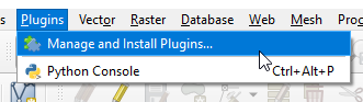
2. Search for GeoCat</strong></p>
<img alt="../_images/geocat-plugin-2.png" src="../_images/geocat-plugin-2.png" />
<img alt="../_images/spacer11.png" src="../_images/spacer11.png" />
<p><strong>
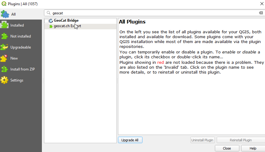
3. Select and click the Install Plugin button.</strong></p>
<p>
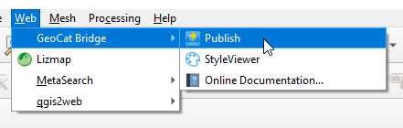
GeoCat Bridgeshould now be available in the Web menu</p>
</div>
<div class="section" id="add-server">
<h2><a class="toc-backref" href="#id5">Add Server</a><a class="headerlink" href="#add-server" title="Permalink to this headline">¶</a></h2>
<p><strong>
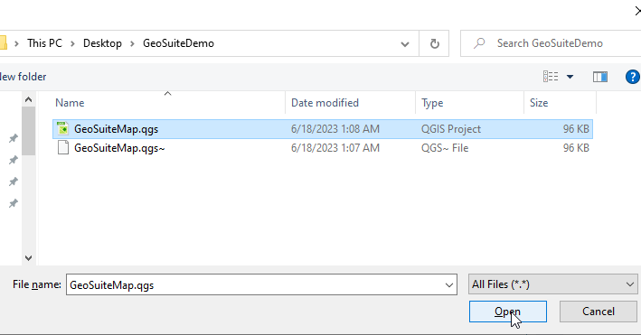
1. If not already open, open the GeoSuite.qgs project</strong></p>
<img alt="../_images/13-Add-Project.png" src="../_images/13-Add-Project.png" />
<img alt="../_images/spacer11.png" src="../_images/spacer11.png" />
<p><strong>2. In the top menu, go to Web &gt; GeoCat &gt; Publish</strong></p>
<img alt="../_images/geocat-1.png" src="../_images/geocat-1.png" />
<img alt="../_images/spacer11.png" src="../_images/spacer11.png" />
<p><strong>3. In the left menu, select Servers</strong></p>
<img alt="../_images/geocat-2.png" src="../_images/geocat-2.png" />
<img alt="../_images/spacer11.png" src="../_images/spacer11.png" />
<p><strong>
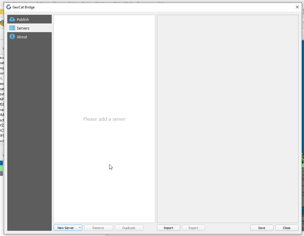
4. Select GeoServer from the New Server dropdown at bottom</strong></p>
<img alt="../_images/geocat-3.png" src="../_images/geocat-3.png" />
<img alt="../_images/spacer11.png" src="../_images/spacer11.png" />
<p><strong>
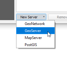
5. Enter a name and your GeoServer url.  We’ll leave the rest as default for now.   Click the + button to add new authentication as shown below</strong>.</p>
<img alt="../_images/geocat-4.png" src="../_images/geocat-4.png" />
<img alt="../_images/spacer11.png" src="../_images/spacer11.png" />
<p><strong>
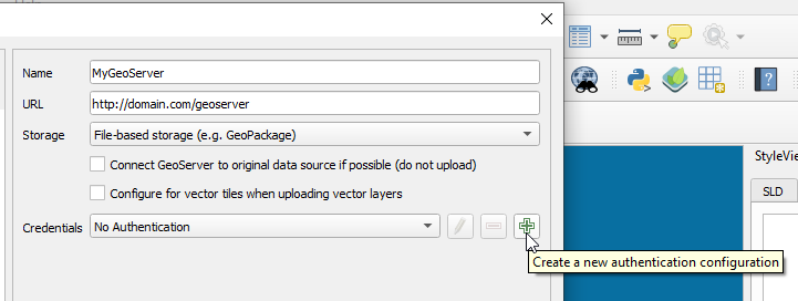
6. In the authentication form, enter admin and your GeoServer admin password</strong></p>
<img alt="../_images/geocat-5.png" src="../_images/geocat-5.png" />
<img alt="../_images/spacer11.png" src="../_images/spacer11.png" />
<p><strong>
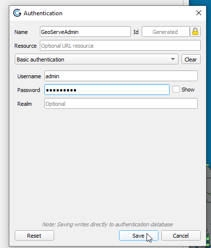
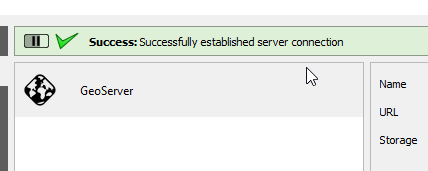
7. Click Test Connection</strong></p>
<img alt="../_images/geocat-6.png" src="../_images/geocat-6.png" />
<img alt="../_images/spacer11.png" src="../_images/spacer11.png" />
<p><strong>
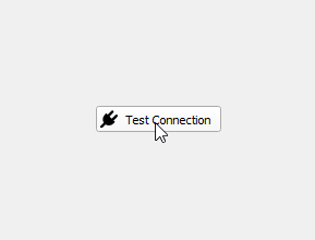
8. Click Test Connection</strong></p>
<img alt="../_images/geocat-7.png" src="../_images/geocat-7.png" />
<img alt="../_images/spacer11.png" src="../_images/spacer11.png" />
<p><strong>
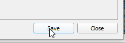
9. Click the Save button at bottom right</strong></p>
<img alt="../_images/geocat-8.png" src="../_images/geocat-8.png" />
<img alt="../_images/spacer11.png" src="../_images/spacer11.png" />
<p><strong>10. Click the Publish tab on the left menu to display your QGIS project layers</strong></p>
<img alt="../_images/geocat-9.png" src="../_images/geocat-9.png" />
<img alt="../_images/spacer11.png" src="../_images/spacer11.png" />
<p><a href="#id1"><span class="problematic" id="id2">**</span></a>
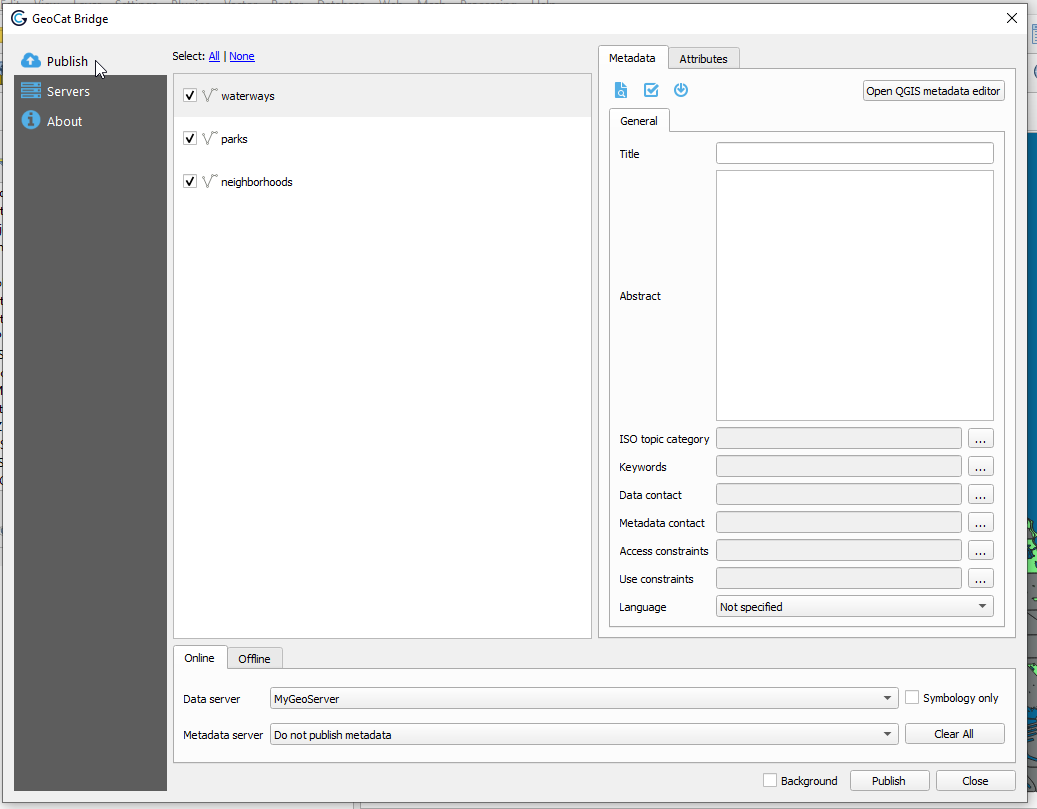
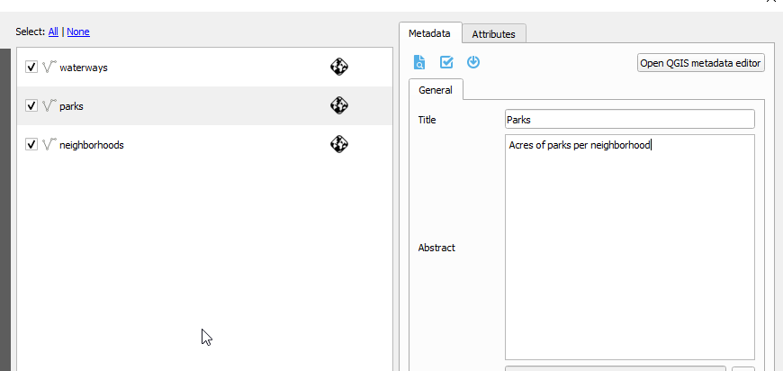
11. On the Metadata tab at right, enter a name, abstract and any other parameters you wish to.  **</p>
<img alt="../_images/geocat-10.png" src="../_images/geocat-10.png" />
<img alt="../_images/spacer11.png" src="../_images/spacer11.png" />
<p><strong>
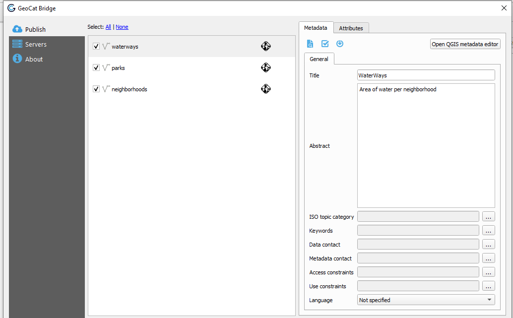
12. Repeat above for each layer</strong></p>
<img alt="../_images/geocat-10-2.png" src="../_images/geocat-10-2.png" />
<img alt="../_images/spacer11.png" src="../_images/spacer11.png" />
<p><strong>
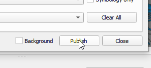
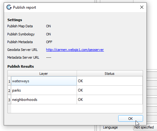
13. Click the Publish button at bottom:</strong></p>
<img alt="../_images/geocat-12.png" src="../_images/geocat-12.png" />
<img alt="../_images/spacer11.png" src="../_images/spacer11.png" />
<p><strong>14. The publication process will display as below</strong></p>
<img alt="../_images/geocat-13.png" src="../_images/geocat-13.png" />
<img alt="../_images/spacer11.png" src="../_images/spacer11.png" />
<p><strong>
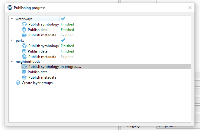
15. Upon completetion you should see the status for each layer:</strong></p>
<img alt="../_images/geocat-14.png" src="../_images/geocat-14.png" />
<img alt="../_images/spacer11.png" src="../_images/spacer11.png" />
</div>
<div class="section" id="view-layers">
<h2><a class="toc-backref" href="#id6">View Layers</a><a class="headerlink" href="#view-layers" title="Permalink to this headline">¶</a></h2>
<p><strong>
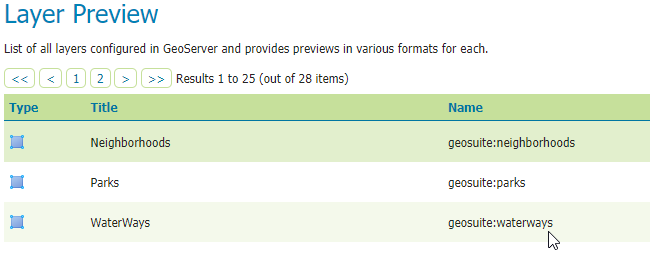
1. Navigate to your GeoServer instance and click on Layers</strong></p>
<p><strong>2.  Your layers should now appear as below:</strong></p>
<img alt="../_images/geocat-15.png" src="../_images/geocat-15.png" />
<img alt="../_images/spacer11.png" src="../_images/spacer11.png" />
<div class="admonition note">
<p class="first admonition-title">Note</p>
<p class="last">When publishing layers to GeoServer using GeoCat Bridge, a new workspace is created using the name of qgs project file.  As you can see above, workspace ‘geosuite’ was created and our layers were published to this workspace.</p>
</div>
</div>
<div class="section" id="styles">
<h2><a class="toc-backref" href="#id7">Styles</a><a class="headerlink" href="#styles" title="Permalink to this headline">¶</a></h2>
<p>One of the best features of GeoCat Bridge is that it published Styles along with the layers.</p>
<p>
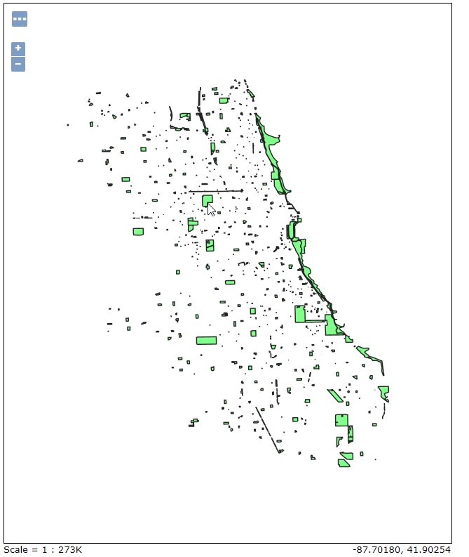
As we can see below, our Parks is using the style we selected in QGIS</p>
<img alt="../_images/geocat-styles-2.png" src="../_images/geocat-styles-2.png" />
<img alt="../_images/spacer11.png" src="../_images/spacer11.png" />
<p>
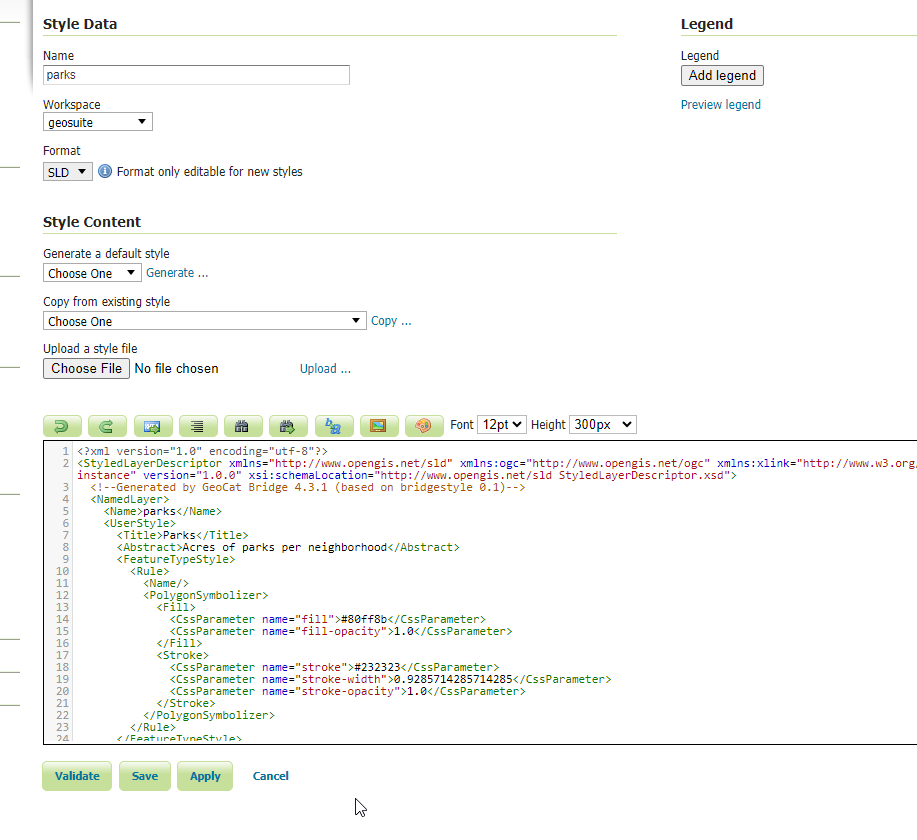
The Styles can be viewed and edited in the Style menu:</p>
<img alt="../_images/geocat-styles.png" src="../_images/geocat-styles.png" />
<img alt="../_images/spacer11.png" src="../_images/spacer11.png" />
</div>
<div class="section" id="publish-styles-only">
<h2><a class="toc-backref" href="#id8">Publish Styles Only</a><a class="headerlink" href="#publish-styles-only" title="Permalink to this headline">¶</a></h2>
<p>If we wish to, we can publish only the styles.  We’ll cover this in the next section</p>
</div>
<div class="section" id="summary">
<h2><a class="toc-backref" href="#id9">Summary</a><a class="headerlink" href="#summary" title="Permalink to this headline">¶</a></h2>
<p>We installed GeoCat bridge in QGIS and used it to publish our PostGIS layers to GeoServer.</p>
</div>
</div>


           </div>
           
          </div>
          <footer>
  
    <div class="rst-footer-buttons" role="navigation" aria-label="footer navigation">
      
        <a href="style-only.html" class="btn btn-neutral float-right" title="Publish Styles Only" accesskey="n" rel="next">Next <span class="fa fa-arrow-circle-right"></span></a>
      
      
        <a href="qgis.html" class="btn btn-neutral float-left" title="Create a QGIS Project" accesskey="p" rel="prev"><span class="fa fa-arrow-circle-left"></span> Previous</a>
      
    </div>
  

  <hr/>

  <div role="contentinfo">
    <p>
        
        &copy; Copyright acugis
      <span class="commit">
        Revision <code>db2a027e</code>.
      </span>

    </p>
  </div>
    
    
      Built with <a href="http://sphinx-doc.org/">Sphinx</a> using a <a href="https://github.com/rtfd/sphinx_rtd_theme">theme</a> provided by <a href="https://readthedocs.org/">Read the Docs</a>. 

</footer>

        </div>
      </div>

    </section>

  </div>
  

  <div class="rst-versions" data-toggle="rst-versions" role="note" aria-label="versions">
    <span class="rst-current-version" data-toggle="rst-current-version">
      <span class="fa fa-book"> Read the Docs</span>
      v: latest
      <span class="fa fa-caret-down"></span>
    </span>
    <div class="rst-other-versions">
      <dl>
        <dt>Versions</dt>
        
          <dd><a href="../index.html">latest</a></dd>
        
      </dl>
      <dl>
        <dt>Downloads</dt>
        
          <dd><a href="http://geohelm.docs.acugis.com/_/downloads/en/latest/pdf/">pdf</a></dd>
        
          <dd><a href="http://geohelm.docs.acugis.com/_/downloads/en/latest/htmlzip/">html</a></dd>
        
          <dd><a href="http://geohelm.docs.acugis.com/_/downloads/en/latest/epub/">epub</a></dd>
        
      </dl>
      <dl>
        
        <dt>On Read the Docs</dt>
          <dd>
            <a href="http://readthedocs.org/projects/geohelm/?fromdocs=geohelm">Project Home</a>
          </dd>
          <dd>
            <a href="http://readthedocs.org/builds/geohelm/?fromdocs=geohelm">Builds</a>
          </dd>
      </dl>
    </div>
  </div>


  <script type="text/javascript">
      jQuery(function () {
          SphinxRtdTheme.Navigation.enable(true);
      });
  </script>


</body>

<!-- Mirrored from geohelm.docs.acugis.com/en/latest/qgis/publish.html by HTTrack Website Copier/3.x [XR&CO'2014], Thu, 13 Jul 2023 23:23:09 GMT -->
</html>